Our Stony Creek, Connecticut - Now and Then
The Creek - a Maine village in disguise
BJ’s – A New Battle
Here’s an apolitical attempt to outline the history of the Wayne Cooke Hilltop Orchard property.
I’ve attempted to carefully document the Hilltop Orchards history using AI – without political bias.
Here are the results:
The Cooke family ownership of Hilltop Orchards in Branford, Connecticut, spans roughly 140 years, initiated by Samuel Griffing Cooke in the 19th century and managed across multiple generations before closing the retail landmark in 2004 and navigating subsequent land and tax battles. [1, 2, 3]
Founding and Early Ownership
- Samuel Griffing Cooke (1835–1915): Purchased the 148-acre Griffing farm at East Main Street and Leetes Island Road, starting the fruit-growing enterprise that became Hilltop Orchards.
- 1868: Samuel married Cornelia Augusta Palmer, and they raised five children on the property. [2]
Later Generations and Business Closure
- Nelson B. Cooke: A UConn horticulture graduate (class of 1939) who owned and operated the farm alongside family members. [3]
- Wayne Cooke: Represented a later generation (operating alongside family partnerships) and managed the roadside store known for its apple globe and pies. [1, 4]
- December 2004: Hilltop Orchards closed its retail operations on East Main Street for good after nearly 140 years in business, with the family retaining a portion of the remaining acreage. [1, 5]
Tax Disputes and Later Legal Battles
- 2009–2011: The town revoked the property’s agricultural tax classification, causing annual taxes on family partnership parcels to jump from $17,000 to over $85,000, triggering prolonged legal and public protests led by Wayne Cooke. [4, 6]
- 2010–2011: Settlements and selectmen votes partially restored agricultural status to specific parcels (such as 573 E. Main St.) conditional on active farming. [4, 7]
- 2015–2024: Wayne Cooke pursued further litigation against town officials regarding a stalled $5 million land development proposal for Costco, resulting in a jury damage award in early 2024. https://www.nhregister.com/news/article/Is-Branford-forcing-Wayne-Cooke-s-Hilltop-11558481.php
- https://www.nhregister.com/news/article/Hilltop-Orchards-now-part-of-past-11650030.php
- https://www.wsclancy.com/obituaries/Nelson-B-Cooke?obId=2088788
- https://www.nhregister.com/news/article/Branford-Cooke-family-settle-tax-dispute-11600526.php
- http://207.210.128.35/archives758/files/original/5da80b1411d9ed3d1a2b5bda038a7074.pdf
- https://patch.com/connecticut/branford/cooke-takes-billboard-clad-trailor-out-of-service-indefinitly
What were specific parcels of land involved in the Cooke family tax agreements?
The tax agreements and reclassification disputes between the Wayne Cooke family partnerships and the town of Branford involved four non-contiguous parcels of land that historically made up the “farm unit” of Hilltop Orchards. [1]
When the town revoked the farm status under the Public Act 490 program, the total tax bill across these combined properties skyrocketed from roughly $17,000 to over $85,000 annually. The specific parcels addressed in the subsequent Board of Assessment Appeals rulings and court settlements include: [1, 2, 3, 4, 5]
The Two Larger Parcels (The Core Dispute)
- 573 East Main Street: A 21-acre parcel located south of Route 1 (identified in town property records as Assessor’s Map J04, Block 002, Lot 0001). Under a 2010 stipulated court agreement, the town agreed to restore its farmland tax classification, conditional upon the family actively farming the land and keeping the ownership structure intact. [2, 3, 6]
- 616 East Main Street: A 16.91-acre parcel located north of Route 1, which contained Wayne Cooke’s residential home. The initial 2010 agreement reclassified this section as commercial property, though later omnibus legal resolutions in 2014 allowed it to tentatively regain farmland tax status for back taxes. [2, 3]
The Two Smaller Parcels
- 61 East Main Street: A smaller piece of land separated from the primary orchard grounds. The Board of Assessment Appeals initially voted to preserve or restore its agricultural farm status during the early 2009 disputes. [1]
- Thimble Island Road (Red Hill Road area): An outlying agricultural parcel tied to the family partnership’s farm unit. Along with the 61 E. Main St. location, this parcel was initially protected by early assessment board decisions, but it faced rolling declassifications and reinstatements before finally being resolved under back-tax reclassifications in late 2014. [1, 3]
- 1. https://caselaw.findlaw.com/court/ct-superior-court/1506328.html
- 2. https://www.nhregister.com/news/article/Battle-rages-on-Hilltop-Orchards-tax-bill-11640455.php
- 3. https://patch.com/connecticut/branford/branford-settles-wayne-cooke-slander-suit-500000-0
- 4. https://www.nhregister.com/news/article/Branford-Cooke-family-settle-tax-dispute-11600526.php
- 5. https://www.nhregister.com/news/article/Branford-s-Wayne-Cooke-files-lawsuits-against-11465335.php
The 16.91-acre parcel at 616 East Main Street (the site containing the historic Cooke residence) was fundamentally shaped by its transition into an IG-2 (General Industrial) Zone and its role in major, highly contested commercial development proposals. [1, 2, 3]
The major commercial zoning milestones and changes affecting this specific parcel include:
Industrial Upzoning (IG-2 Designation)
- The Baseline Shift: The 16.91-acre lot at 616 East Main Street was grouped alongside adjacent Cooke family properties (including 596 East Main) to form a contiguous 20.4-acre block zoned explicitly as IG-2 (General Industrial). [1, 3]
- Permitted Uses: This specific commercial zoning stripped the land of its exclusive agricultural/residential parameters and legally unlocked the footprint for high-density commercial applications, including medical facilities, warehouses, laboratories, and manufacturing hubs. [1]
The Stalled Costco Master Plan
- The Proposal: The property sat directly across Route 1 from a multi-parcel tract spanning over 44 acres that was targeted for a massive commercial retail development. [4]
- Planned Infrastructure: Under the conceptual master plan, the commercial upzoning was intended to support a 158,070-square-foot Costco wholesale club and accessory gas station. This development would have necessitated a new commercial access road intersecting the surrounding infrastructure at I-95’s Exit 56. [4]
- The Fallout: Protracted delays, shifting town mandates, and legal standoffs regarding the scope of the commercial master plan ultimately caused the Costco project to fall through, giving rise to Wayne Cooke’s long-running civil rights litigation against town officials over structural roadblocks.
The Recent Rehabilitation Hospital Pivot (2025–2026)
- Special Exception Requests: With the Costco project defunct, the Cooke family and its associated entities (including NFW Associates) leveraged the commercial IG-2 zoning to pivot the land toward high-density healthcare infrastructure.
- The Project Scope: Under applications submitted to the Branford Planning & Zoning Commission, the family proposed a $69.5 million, 54,765-square-foot inpatient rehabilitation hospital spanning 596, 612, and 616 East Main Street.
- Approvals: The project cleared critical environmental and commercial hurdles, including a unanimous 6-0 approval from the Branford Inland Wetlands and Watercourses Agency to manage site grading, utilities, and stormwater drainage for the facility. [1, 2, 5, 6, 7, 8]
.
- 1. https://www.branford-ct.gov/AgendaCenter/ViewFile/Minutes/_06042026-3735
- 2. https://www.branford-ct.gov/AgendaCenter/ViewFile/Agenda/_07232026-3839
- 3. https://geentygroup.com/properties/240-Land-596-616-East-Main-Street-Branford-Connecticut-06405-USD6-018-000/
- 4. https://geentygroup.com/properties/240-Land-596-616-East-Main-Street-Branford-Connecticut-06405-USD6-018-000/
- 5. https://www.nhregister.com/news/article/branford-rehab-hospital-hearing-encompass-health-22320878.php
- 6. https://www.branford-ct.gov/AgendaCenter/ViewFile/Minutes/_03122026-3347
- 7. https://www.branford-ct.gov/AgendaCenter/ViewFile/Minutes/_03262026-3462
History of 569 and 573 East Main leading to BJ’s proposal.
The property at 573 East Main Street—historically the 21-acre agricultural core of the Cooke family’s Hilltop Orchards south of Route 1—serves as the primary link between the family’s past land battles and a massive commercial development centered around a BJ’s Wholesale Club. [1, 2]
The historical timeline and development pivot of the 573 East Main Street parcel includes:
The Agricultural Tax Battle
- The Reclassification Dispute: In 2009, the town revoked the property’s Public Act 490 agricultural status, triggering years of legal battles led by Wayne Cooke.
- The 2010 Restored Status: Under a 2010 stipulated court agreement, the town agreed to restore 573 East Main Street’s farmland tax classification, conditional on active farming. This agreement protected the 21-acre parcel while surrounding properties began shifting toward commercial zoning.
The Failed Costco Era (2015–2017)
- The Original Proposal: In February 2015, plans were filed to transform 573 East Main Street and adjacent properties into a large-scale commercial hub anchored by a 158,000-square-foot Costco Wholesale store. [3]
- Environmental Opposition: The proposal faced severe public and regulatory backlash, including intense Inland Wetlands Commission hearings where residents raised concerns regarding watershed damage and a proposed gas station near the wetlands. [4]
- Project Collapse & Lawsuit: Stalled by town mandates, Costco withdrew its plans in 2017. Wayne Cooke subsequently sued the town, claiming planning officials intentionally sabotaged a $5 million land sale to Costco. In March 2024, a Superior Court judge awarded Cooke $202,000 in damages. [5]
The BJ’s Wholesale Club Proposal
- A New Master Plan: A developer filed formal applications with the Branford Planning and Zoning Commission to revive the defunct Costco site. The new master plan seeks to develop the vacant acreage spanning 569 and 573 East Main Street.
- The BJ’s Footprint: The new proposal features a 106,700-square-foot BJ’s Wholesale Club with an attached liquor store.
- Expanded Commercial Infrastructure: To complement the warehouse club, the developer’s layout introduces an 8-pump (16-car) BJ’s Gas Station along East Industrial Road. It also specifies a 7,000-square-foot sit-down restaurant, two 2,800-square-foot fast-food buildings with drive-thrus, and a 16,000-square-foot retail strip plaza at the corner of Leetes Island Road and East Main Street.
- Next Steps: Because the local commission does not convene in August, the earliest formal independent evaluation of the BJ’s master plan is slated for the September 3, 2026 commission agenda. [2, 5, 6, 7]
- https://www.nhregister.com/business/article/Opposition-to-Branford-Costco-plan-cites-11336928.php
- https://www.yahoo.com/news/us/articles/bjs-wholesale-club-planned-branford-100000710.html
- https://www.greenwichtime.com/business/article/bjs-wholesale-club-branford-costco-site-proposal-22359363.php
- https://www.facebook.com/theconnecticutscoop/photos/new-brooklyn-scoopa-new-tenant-is-coming-to-the-former-ford-dealership-in-brookl/997307289539056/
- https://www.facebook.com/theconnecticutscoop/posts/new-branford-scoop%EF%B8%8Fa-new-retail-development-with-a-bjs-wholesale-club-is-being-p/1102778408991943/
- https://patch.com/connecticut/branford/massive-commercial-development-eyed-branford
- https://www.nhregister.com/business/article/bjs-wholesale-club-branford-costco-site-proposal-22359363.php
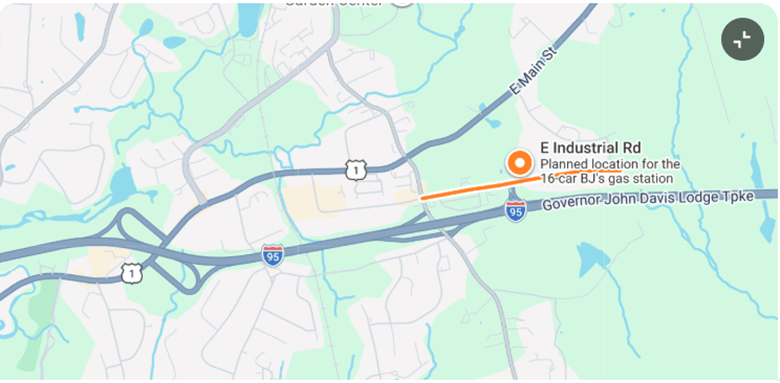
Traffic and infrastructure changes planned for the East Industrial Road intersection
The traffic and infrastructure upgrades planned around the East Industrial Road intersection (near I-95’s Exit 56) are a mix of town-initiated road reconstruction and developer-driven site modifications meant to accommodate the massive commercial traffic from the proposed BJ’s Wholesale Club retail development. [1, 2, 3]
The primary changes planned for the immediate area include:
1. Full-Depth Road Reconstruction (Town Project)
- Rebuilding the Road: The town of Branford is currently executing a full-depth, ground-up reconstruction of East Industrial Road. [4, 5]
- Drainage and Streetscape: The project involves replacing the entire sub-surface stormwater drainage system and installing modern sidewalks to improve pedestrian connectivity. [5]
- Traffic Flow: To minimize disruptions during peak hours, heavy construction is restricted Monday through Friday between 7:00 AM–9:00 AM and 3:00 PM–6:00 PM. The active traffic detours are scheduled to remain in place through October. [5, 6]
2. Dedicated Exit 56 Ramps & Signal Modifications (Developer Proposal)
- Direct Highway Access: Under the overarching master layout for the site, developers plan to construct a direct access drive linking East Industrial Road to the I-95 Southbound Exit 56 ramps. This is engineered to siphon heavy highway traffic directly into the commercial zone before it conflicts with local roads. [2]
- Traffic Signal Upgrades: The massive spike in volume will require a modification of the existing traffic signals at the East Industrial Road intersection. The developer proposes upgrading the hardware and modifying signal timing to coordinate with peak warehouse-club shopping hours. [2, 6]
3. Separation of Fuel and Retail Traffic
Gas Station Placement: The developer, Sound Development Group LLC, intentionally split the vehicle layout. The main 106,700-square-foot BJ’s store fronts East Main Street, while the high-turnover 8-pump (16-car) BJ’s Gas Station is positioned directly along East Industrial Road.
Mitigating Congestion: By moving the fueling center to East Industrial Road, the design aims to prevent fuel-line backups from spilling over and gridlocking the main corner intersection at East Main Street and Leetes Island Road, which local leaders note already suffers from severe traffic congestion. [1, 7, 8, 9, 10]
2. https://www.nhregister.com/business/article/Opposition-to-Branford-Costco-plan-cites-1133692 3.https://www.instagram.com/p/DbLWeSMju2l/8.php
6. https://www.branford-ct.gov/DocumentCenter/View/2503
Schooner Tom Beattie
 Schooner Tom Beattie. Built in 1884 in Bath, Maine by the Beattie quarry family. Pictured here, probably in the late 1890s, sailing near Wheeler Island in the Thimble Islands.

